On this page
Closed consultation

Submit feedback to
Mark
Moloney
Department of Defence
Proposed airspace changes to YMMM/R125A/B also require changes to affected Instrument Approach Procedures (IAP) at Royal Australian Air Force (RAAF) base Learmonth.
The issue
High Intensity Radio Frequency (HIRF) exposure standards limit exposure to prevent human harm (thermal stress) and protect aviation safety systems.
To protect aircraft from high intensity radiated fields generated by military radar operations, changes to restricted airspace R125A/B are required. These airspace changes will affect instrument approaches into Learmonth.
Purpose
To consult industry prior to making changes to restricted airspace R125A/B and subsequently changing the affected IAP at Learmonth.
The purpose of this Airspace Change Proposal (ACP) is to change the lateral and vertical limits of R125A, R125B, and add a new tier proposed as R125C. These changes are required to protect aircraft from high intensity radiated fields created by military radar operations.
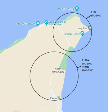
Three Special Use Airspace (SUA) currently exist for non-flying military operations at Harold E Holt Defence Precinct (HEH), refer to Table 1 and Figure 1:
| SUA Name / Status | Lateral Limits | Vertical Limits in feet above mean sea level (ft AMSL) | Hours of Activity | Controlling Authority |
|---|---|---|---|---|
| YMMM/R122 North West Cape RA3 | 2 nautical mile (n mile) circle radius of:
214900S 1140930E |
surface (SFC) - 3000 | H24 | MSCSPO NCS HEH |
| YMMM/R125A North West Cape RA3 |
2.5 n mile circle radius of: 215330S 1140730E |
SFC - 1000 | H24 | 1 RSU OPS FLTCDR |
|
YMMM/R125B North West Cape RA3 |
2.5 n mile circle radius of: 215330S 1140730E |
1000 - 7500 | H24 or as amended by NOTAM | 1 RSU OPS FLTCDR |
The existing airspace volume is insufficient to protect aircraft, pilots and passengers from future military non-flying operations (high intensity radiated fields).
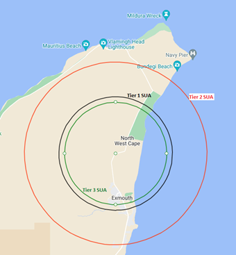
PROPOSED CHANGES
R125A/R125B. Proposed Changes to R125A/R125B:
- Re-centre on 21°53'25.09"S, 114° 7'7.85"E
- Change the control authority to XO 1SSU
- Add/adjust tiers per Table 1, and Figure 2
R125C. New R125C:
- Centre on 21°53'25.09"S, 114° 7'7.85"E
- Control authority to 1SSU XO
- New tier per Table 1, and Figure 2
| SUA Name / Status | Lateral Limits | Vertical Limits | Hours of Activity | Controlling Authority |
|---|---|---|---|---|
| YMMM/ R122 North West Cape RA3 | NO CHANGE | NO CHANGE | NO CHANGE | NO CHANGE |
| YMMM/R125A North West Cape RA3 |
2.85 n mile circle radius |
SFC - 1500 ft AMSL | H24 | I SSU XO |
| YMMM/R125B North West Cape RA3 | 4.56 n mile circle radius | 1500 ft AMSL - FL135 | H24 | |
|
YMMM/R125C North West Cape RA3 |
2.57 n mile circle radius | FL135 - FL200 | H24 |
IMPACTS ON AERODROMES
Learmonth.
Learmonth aerodrome (YPLM) is a military aerodrome located approximately 20 n mile (38 kilometres (km) south of the HEH. YPLM is usually a non-controlled aerodrome except during major military exercises. YPLM has instrument approach and departure procedures published in the Australian Aeronautical Information Publication (AIP) for use by civilian and military aircraft, and in Australian Defence Force - Flight Information Publication (ADF-FLIP) Terminal Australia (TERMA) for use by Australian and Foreign military aircraft as authorised by the Australian Department of Defence.
Instrument Flight Rules (IFR) Circling areas. The maximum horizontal distance that Category D circling area may extend for an aerodrome in Australia is 5.28 n mile (9.79 km) from the threshold of each usable runway. The threshold for YPLM Runway 18 (RWY18) is located 15 n mile from the lateral limit of proposed airspace. The lateral extent of the proposed airpsace is beyond the limits of the Category D circling limits and will not impact these flight operations at YPLM.
Obstacle Limitation Surfaces (OLS). YPLM RWY18 / Runway 36 (RWY36) are classed as Code 4 non-precision instrument RWY’s. The proposed airspace is located outside the horizontal extent and does not impact the OLS
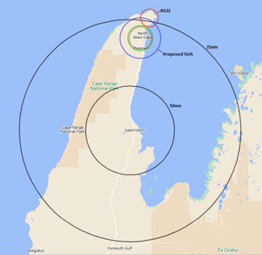
PANS-OPS Surfaces. The proposed airspace is within the YPLM 25 n mile Minimum Safe Altitude (MSA). The lateral and vertical limits of the SUA are above the MSA altitudes. It is pilot and air traffic control responsibility to ensure aircraft are kept clear of the relevant SUA. Refer to Figure 3.
Instrument Approach Procedures. Amendments to the following instrument approach procedures are required:
- RNAV-Z (GNSS) RWY 18. The straight initial approach fix (PLMNE) is located 15.3 n mile from the threshold of R18, approximately coincident with the lateral limit of the Tier 2 SUA area. The minimum initial approach altitude is 2000 ft and the on-glide path altitude at the IAFs is approximately 4970 ft based on the published 3° glide path. The proposed new R125B (Tier 2), with an upper altitude of FL135 and a lateral limit of 4.56 n mile would prevent aircraft from being able to use this approach leg. Aircraft intending to use this IAF need to track with 30° of the initial track. The old R125B, with an upper limit of 7500 feet AMSL and a lateral limit of 2.5 n mile also prevented aircraft from using the PLMNE IAF. However, aircraft arriving from the north would easily avoid the SUA by using the PLMND or PLMNG IAFs. The removal of the straight initial approach leg would not create an adverse impact to aircraft conducting this instrument approach procedure
- The PANS-OPS surfaces (and required altitudes to be able to use the procedure) for the holding pattern at PLMNG would infringe the proposed SUA. Moving the initial approach fix (IAF) along the same initial approach track to a point where the holding pattern PANS-OPS surfaces would be clear of the proposed SUA would impose extra track miles for aircraft arriving from the south but provide an advantage to aircraft arriving from the northeast. An alternative would be to realign the PLMNG initial approach leg to a 90° left turn at the intermediate approach fix PLMNI and increasing the length of the initial approach leg to 7 n mile would likely avoid the proposed SUA, recommendation:
- Delete the straight initial approach segment from PLMNE
- Adjust the holding pattern at PLMNG to accommodate the proposed SUA by increasing the length of the initial approach segment from PLMNG to accommodate the minimum holding altitude
- YPLM DME or GNSS Arrival Procedure. Consider redesigning this procedure by changing the Sector boundaries of each sector to ensure avoidance of the proposed R125B (Tier 2).
- YPLM NDB-A or VOR-A. The approach segments are located south of YPLM with the missed approach tracking straight-ahead on a track of 347°M towards the proposed SUA. PANS-OPS tolerance areas would infringe the proposed SUA. Redesigning the missed approach track to turn either side of the proposed and existing SUA would eliminate the infringement without significant impact to IFR flight operations. A right turn would be preferable due to the no-circling area west of the RWY, recommendation:
- Adjust missed approach track to ensure avoidance with the proposed SUA by the appropriate margin specified in Civil Aviation Safety Regulations (CASR) Part 173 Manual of Standards
- YPLM VOR RWY 18. The straight initial segment would not be available when the proposed SUA is promulgated due to track intercept angles and descent gradients from overhead the proposed and existing SUA, recommendation:
- Removal of the straight initial approach segment may be required but will not reduce the usability of this procedure.
- YPLM VOR RWY 36. All of the approach segments are located to the south of YPLM. The missed approach tracks toward the proposed SUA. A minor adjustment to the missed approach track would avoid any likelihood of an intrusion into the proposed SUA, recommendation:
- Adjust missed approach track to ensure avoidance with the proposed SUA by the appropriate margin specified in CASR Part 173 Manual of Standards.
| YPLM Approach Procedure | SUA Impact | Mitigation | Impact After Mitigation |
|---|---|---|---|
| DME or GNSS Arrival | Procedure allows IFR aircraft to avoid the proposed SUA | Nil required but sectors could be redesigned to avoid the SUA’s if necessary | ACFT can adjust track to avoid the proposed SUA. Nil impact |
| RNAV-Z (GNSS) RWY 18 | Descent gradient and intercept angle requirements prevent aircraft using the straight initial approach fix (PLMNE) | Remove straight initial approach segment | Nil Impact. Aircraft are unable to use the straight initial approach segment at present |
| Holding pattern at PLMNG’s PANS-OPS surface will infringe the proposed SUA | Extend the left hand initial approach segment to ensure holding pattern at PLMNG is clear of the proposed SUA | Minor impact due to some additional track miles to be flown by some aircraft but fewer for other aircraft. For aircraft arriving from the northeast – easier access around the SUA | |
| RNAV-Z (GNSS) RWY 36 | Nil | N/A | N/A |
| NDB-A or VOR-A | The missed approach tracks towards SUA and aircraft are unable to climb above the SUA at boundary | Realign missed approach track to avoid SUA’s | Nil impact. Aircraft can track as desired outside of the SUA after the missed approach |
| VOR RWY 18 | Nil | N/A | N/A |
| VOR RWY 36 | The missed approach tracks towards SUA and aircraft are unable to climb above the SUA at boundary | Realign missed approach track to avoid SUA | Nil impact. Aircraft can track as desired outside of the SUA’s after missed approach |
| ARA RWY 18 | Nil | N/A | N/A |
| ARA RWY 36 | The missed approach tracks towards SUA and aircraft are unable to climb above the SUA at boundary | Realign missed approach track to avoid SUA | Nil impact. Aircraft can track as desired outside of the SUA after missed approach. |
| IFR CIRCLING AREA’s | Nil | N/A | N/A |
Uncertified Aerodromes in the vicinity of the proposed SUA
There are two uncertified aerodromes on the Exmouth Peninsula north of YPLM aerodrome. As a general guide an area of 3 n mile radius from the runway ends at uncertified aerodromes is used to assess external impacts to operations.
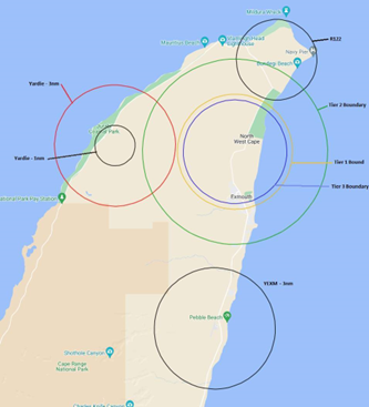
Yardie Aerodrome. Yardie aerodrome is located approximately 6.1 n mile west from the proposed centre of the SUA and approximately 1.5 n mile from the western boundary of the proposed lateral limit to R125B. Yardie aerodrome caters for tourists to the coastal areas to the west of the Exmouth Peninsula who generally arrive by airline type aircraft into YPLM and then by light aircraft to/from Yardie aerodrome. Flight operations at Yardie are typically contained within 1 n mile of each runway threshold and can operate at a height of 1000 ft AGL, beneath the lower limit of the R125B area.
Whilst the proposed Tier 2 area of the proposed SUA is coincident with the 3 n mile area surrounding Yardie aerodrome, the proposed SUA is unlikely to have an impact on flight operations due to the option of operating to the west of the aerodrome.
Exmouth Aerodrome. Exmouth aerodrome is located approximately 8.9 n mile south of the proposed centre of all airspace and approximately 4.5 n mile from the southern boundary of R125B. It services the local community and provides for aeromedical evacuation in the event of a serious accident or illness occurring in the area. Exmouth aerodrome is located outside the 3 n mile assessment area and therefore would not have any impact on flight operations at Exmouth aerodrome.
Summary. Flight operations at Exmouth and Yardie aerodromes would not be adversely impacted by the proposed SUA.
IFR AIR ROUTES
There are several IFR air routes overhead of the proposed SUA all converging on YPLM. They are published by Airservices Australia as a component of the AIP. Enroute Charts High (ERCH) contain the details of significant air routes used by transcontinental, inter-capital and international air traffic for flight operations above FL200. Enroute Charts Low (ERCL) contain the details of air routes used by local aircraft up to and including FL200.
All IFR air routes that exist overhead the existing and proposed SUA originate or terminate at YPLM. For IFR aircraft overflying YPLM to other destinations above FL200 there is no impact. An IFR aircraft overflying the proposed SUA and intending to land at YPLM will either:
- continue to track to YPLM while maintaining an altitude above the existing or proposed SUA until clear of the SUA or overhead the YPLM navigation aids before commencing an instrument approach from overhead the YPLM navigation aids, or;
- track off the air route once within the 25 n mile MSA or as cleared by ATC, toward the appropriate initial approach fix (IAF). Consideration of the extent of the SUA to be avoided would be a primary consideration for pilots. The current IAFs available for the various instrument approaches at YPLM provide sufficient waypoints to avoid the SUA without significant increases to track miles flown.
For IFR aircraft that are departing YPLM to join an air route, they must establish themselves on track within 5 n mile of the aerodrome and remain clear of the SUA lateral and vertical limits. The proposed SUA is located at an adequate distance to enable IFR aircraft to establish themselves on track within allowable limits.
Proposed Designated Airspace Handbook (DAH) entry. The proposed changes / amendments to DAH are listed as follows:
YMMM/R125A NORTH WEST CAPE
- CONDITIONAL STATUS: RA3
- COMMUNICATIONS
- LATERAL LIMITS: A circle of radius 2.85 n mile centre 21°53'25.09"S, 114° 7'7.85"E
- VERTICAL LIMITS: SFC - 1500
- HOURS OF ACTIVITY: H24
- CONTROLLING AUTHORITY: XO 1SSU
YMMM/R125A NORTH WEST CAPE
- CONDITIONAL STATUS: RA3
- COMMUNICATIONS
- LATERAL LIMITS: A circle of radius 4.56 n mile centre 21°53'25.09"S, 114° 7'7.85"E
- VERTICAL LIMITS: 1500 - FL135
- HOURS OF ACTIVITY: H24
- CONTROLLING AUTHORITY: XO 1SSU
YMMM/R125A NORTH WEST CAPE
- CONDITIONAL STATUS: RA3
- COMMUNICATIONS
- LATERAL LIMITS: A circle of radius 2.57 n mile centre 21°53'25.09"S, 114° 7'7.85"E
- VERTICAL LIMITS: FL135 - FL200
- HOURS OF ACTIVITY: H24
- CONTROLLING AUTHORITY: XO 1SSU
ENVIRONMENTAL ASSESSMENT
The airspace remains non-flying activity and has no environmental impact