On this page

Submit feedback to
Proposed airspace changes following a review of West Head Gunnery Range (WHGR).
The issue
The Australian Defence Force requests feedback on proposed airspace changes.
Some key details of the proposal include:
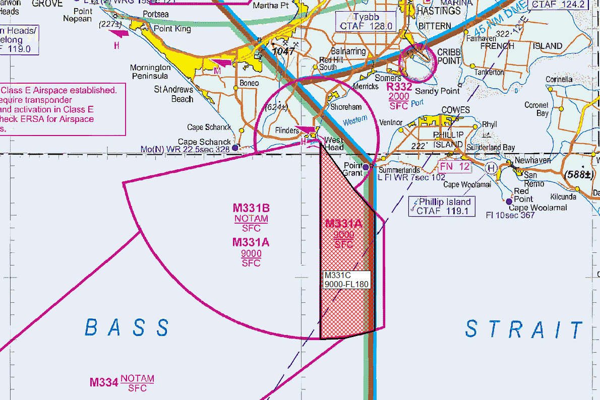
- Defence proposes the WHGR airspace consist of three sections. M331A (reduced); M331B (no change); and M331C (new)
- to achieve the desired training outcomes, the lowest usable level (LUL) on the eastern edge of M331A is required to be raised to Flight Level (FL) 180
- the Eastern edge of M331A (0.7 nautical miles east of the Melbourne Class E Frequency boundary) is to be removed
- Defence intends to conduct training as per current activations of M331AB (2-3 instances per week for approximately 3 hours per activation)
- M334 is proposed to be disestablished.
Purpose
Defence is seeking feedback following a review of the airspace associated with the WHGR and proposing to vary the vertical and lateral boundary to encapsulate the activities safely.
Proposal
Defence is seeking feedback following a review of the airspace associated with the WHGR and proposing to vary the vertical and lateral boundary to encapsulate the activities safely.
Following a review of M331 Western Port and M334 Cape Shank airspace volumes, Defence proposed the following changes.
M331A to have the South Eastern edge aligned with the Class E Frequency volume and the Eastern edge of the proposed M331C. M331C, see image, proposed to increase the effective arc of operation of the training equipment to provide a safe operating area for Defence training activities and activated in conjunction with M331B. M331B shall remain extant. In addition, Defence intends to disestablish M334, as it is no longer required for Defence purposes.
Defence is seeking feedback on the proposed changes to the airspace as per the following definitions:
- M331A – boundary variance
Military flying/non-flying
Lateral limits: 383223S 1444141E - 383000S 1445522E then along the clockwise arc of a circle radius 5 nautical miles centred on 382855S 1450135E - 383252S 1450528E - 383444S 1450738E - 384413S 1450738E then along the clockwise arc of a circle radius 16 nautical miles centre
382855S 1450135E - 383223S 1444141E
Vertical limits: SFC - 9000 feet above mean sea level
Hours of activity: Notice to Airmen (NOTAM)
Administering authority: Navy HMAS Cerberus - M331B – No change
Military flying/non-flying
Lateral limits: 382855S 1450135E - 383223S 1444141E then along the counterclockwise arc of a circle radius 16 nautical mile centred on 382855S 1450135E - 384455S 1450200E
382907S 1450200E - 382855S 1450135E
Vertical limits: surface - NOTAM
Hours of activity: NOTAM
Administering authority: Navy HMAS Cerberus - M331C – new volume
non-flying
Lateral Limits: 382907S 1450200E - 383252S 1450528E - 383444S 1450738E -
384413S 1450738E then along the clockwise arc of a circle radius 16.00 nautical miles centre 382855S 1450135E - 384455S 1450200E - 382907S 1450200E
Vertical Limits: 9000-FL180
Hours of Activity: NOTAM
Controlling Authority: Navy HMAS Cerberus
