On this page
Closed consultation

Submit feedback to
Jason
Somerville-Kimlin
Gympie Regional Council
Proposal to establish a discrete frequency for use for operations in the vicinity of Gympie aerodrome (YGYM).
The issue
- Historically: Safety issues at Gympie Aerodrome have been known for many years. Fatal aircraft accidents have occurred in the vicinity of the aerodrome. The aerodrome operator referenced the safety issues at meetings of Council and CASA in 2017 where a number of mitigations were identified – a CTAF change was one of them. This proposal addresses the CTAF change.
- Aerodrome layout: There are two runways at Gympie. A shorter one intersects the main one at one end. Due to a sloping main runway, the end where the intersection is and the crossing runway cannot be seen from the downhill end of the main runway. There are no parallel taxiways or turning nodes – aircraft have to taxi/backtrack on the runways and sometimes on the grass verge adjacent. Runway occupancy times introduce on-ground waits, in-flight delays and go-arounds which are not only inconvenient and fuel-wasting, they compound the exposure to risks. Timely radio communication between pilots is therefore crucial to identify where aircraft are at any point in time and their intentions so as to prevent a collision or near-miss.
- Traffic mix: Present aerodrome traffic includes General Aviation and Recreational Aviation Australia (RAAus) fixed wing aircraft, warbirds, rotary wing, and skydiving. Symbology on official aeronautical charts currently shows skydiving, winch- or auto-towed gliders, and ultralights. Aerobatic training is yet to be charted. An aerial fire-fighting base has been established at the aerodrome.
- Airspace consequences: The controlled airspace around Sunshine Coast Airport (YBSU) necessitates Class C steps to the southeast of Gympie Aerodrome. As a consequence, more aircraft are bypassing to the west of that airspace and passing closer to Gympie with a corresponding increase in transiting radio calls.
- Frequency congestion: The present 126.70 MHz frequency for Gympie Aerodrome is shared with multiple charted and uncharted aerodromes in Class G airspace. Pilot confusion on 126.70 MHz for separation purposes has been reported and observed. The higher that aircraft are flying, the greater the range of their VHF transmitter and the ability to over transmit other aircraft a considerable distance away. A missed radio call can significantly reduce a pilot’s situational awareness.
Purpose
OVERVIEW
YGYM is a non-controlled airport situated 7 nautical miles (NM) south-southeast of Gympie township in Class G airspace. “Non-controlled” means Gympie is not monitored by Air Traffic Control. To avoid collisions, pilots are required to self-separate. Pilots do so primarily by visual means (looking out the window) and by listening to radio transmissions made by other pilots (alerted see-and-avoid). The latter relies on all aircraft listening to the same VHF radio frequency and being heard, and pilots having situational awareness of their own aircraft and others in close proximity.
Congestion
A problem occurs when aircraft using other airports transmit on the same radio frequency which can be heard at Gympie, unintentionally blocking or overriding local aircraft transmissions that are located at or near Gympie. The problem is compounded by smaller aircraft tending to have lower-powered VHF transmitters than those fitted to larger aircraft which will transmit a greater distance and can appear to be louder.
Sources of non-Gympie transmissions are becoming more common due to:
- increased aerial tourism over K’Gari (Fraser Island) with a new helicopter scenic operation at Rainbow Beach;
- increased use of the Teewah area for flight training;
- increased scenic helicopter flights at Tangalooma (repetitive 6-minute sorties typically); and
- parachuting just west of Goondiwindi that, when operating, is conducting in excess of 20 drops a day.
It is difficult to measure or record radio frequency congestion as each occurrence depends on the relative positions of all three aircraft at that point in time – the one aircraft listening, and the other two aircraft transmitting simultaneously. Radio monitors on the ground will not necessarily hear what pilots are hearing in the air or elsewhere at the aerodrome.
Appropriate VHF Frequency
The AIP outlines which frequency pilots should be listening to in Class G airspace – this is known as “the appropriate VHF frequency”. Currently at Gympie Aerodrome there is no defined radio broadcast area or discrete CTAF, so radio transmissions by pilots must use the generic Australia-wide CTAF of 126.70MHz when in an area defined as “in the vicinity”.
Civil Aviation Regulation 91.360 explains the vicinity is:
- laterally, within a 10 nautical mile radius of Gympie Aerodrome; and
- vertically, at a height above the aerodrome that could result in conflict with operations at the aerodrome – and at Gympie, that can be as high as FL180.
Infrastructure and traffic at the aerodrome
In the last ten years there has been significant growth and change associated with the aerodrome. Prior to that there were simply local aviators and two flight training schools with low activity.
Currently, at the aerodrome, there are:
- a well-established aviation maintenance workshop;
- an aero club with 65 flying members that conducts regular activities for members and invites other aero clubs and fly-in aviators;
- four flying schools, one of which is an aerobatic school, conducting flights up to A065 with VHF radio range beyond local at those altitudes;
- two helicopter companies regularly conducting low level powerline work;
- two additional helicopter companies that conduct application and fire-fighting operations from the aerodrome;
- a new aerial fire-fighting base constructed on site for the Queensland Fire Department for fixed and rotary wing aircraft; and
- a skydive operation that is becoming busier – over 55 sorties have been recorded in one day with operations up to FL140.
In the vicinity of the aerodrome as defined in the regulations:
- on the ground, there is a helipad (ICAO code YXGY) usable day and night at the hospital in Gympie township, 7NM from the aerodrome; and
- in the air, an instrument flight rules (IFR) waypoint (SEBVA) is close by to the west, and another (SAGLI) on the periphery to the east.
In the immediate future:
- two new airparks are being established adjacent to the aerodrome with at least 100 hangars for aircraft becoming available within one year and another 40 over 2-3 years;
- a hot air balloon operation and a wing-walking operator are being considered for location at the aerodrome; and
- an expected increase in traffic at the aerodrome as operators are moving away from locations at YBSU and Caloundra aerodrome (YCDR).
Other landing sites affected
Some of the key issues include confusion on the radio, changes to the traffic mix, and changes to traffic density. Changing the Gympie Aerodrome CTAF from 126.70 MHz to a discrete frequency will help to reduce the identified risk. It would also improve communications in the vicinity of other aerodromes nearby that will continue to use 126.70 MHz.
Those aerodromes are shown on official aeronautical charts and within 50NM include:
- Cherry Venture YCHV, 28NM northeast – WAC 3340 Brisbane
- Cooloola Cove (no Y-code), 25NM to the northeast – WAC 3340 Brisbane
- Kilcoy YKCY, 42NM south-southwest – WAC 3340 Brisbane, VTC Sunshine Coast, VNC Bundaberg, TAC-1 Brisbane
- Landsborough YLAB, 36NM southeast – WAC 3340 Brisbane, VTC Sunshine Coast, VNC Bundaberg
- Manumbar YMUB, 15NM to the southwest – WAC 3340 Brisbane, VTC Sunshine Coast, VNC Bundaberg
- Murgon YMRG, 42NM west – WAC 3340 Brisbane, VNC Bundaberg, ERC L4, TAC-1 Brisbane
- Nanango YNAN, 46NM to the west-southwest – WAC 3340 Brisbane, VNC Bundaberg, ERC L4, TAC-1 Brisbane
- Noosa YNSH, 21NM to the east – WAC 3340 Brisbane, VTC Sunshine Coast
- Rainbow Beach YRBB, 32NM northeast – WAC 3340 Brisbane, VNC Bundaberg, ERC L4
- Wondai YWND, 45NM west – WAC 3340 Brisbane, VNC Bundaberg, ERC L4, TAC-1 Brisbane.
In addition, CASA-approved Electronic Flight Bag software shows more helipads and aerodromes, such as:
- Boreen Point airstrip (no Y-code), 14NM east
- Kilkwana hospital helipad YXKL, 28NM to the west-northwest
- Nambour hospital helipad YXNA, 24NM southeast
- Noosa hospital helipad YXNO, 20NM east-southeast
- Noosa North Shore/Teewah airstrip (no Y-code), 18NM to the east.
If endorsed by the aviation community and approved by CASA, a frequency change for Gympie Aerodrome would affect the following:
- All aircraft – any crewed or uncrewed aircraft landing, taking off, transiting or conducting aviation activities in the vicinity of the aerodrome would use the new discrete CTAF instead of 126.70 MHz.
- At Gympie Aerodrome YGYM – the frequency of the airport’s Avdata receiver, and VHF transceivers used by Aerodrome Reporting Officers at the airport, would have to be changed from 126.70 MHz to the new discrete CTAF.
- At Gympie Hospital’s helipad YXGY – all pilot transmissions at and near this facility would use the new discrete CTAF.
- At any private airfields within the vicinity of YGYM – all pilot transmissions at and in the vicinity of those uncharted airstrips would change to the new discrete CTAF.
- Electronic flight bags – CASA-approved apps such as AvPlan and OzRunways would change their frequency details for YGYM, using approved data derived from Airservices Australia.
If the proposal is implemented, there are some additional benefits:
- Within and around the vicinity of YGYM – increased safety with lower distraction and/or lower confusion from radio traffic that is not relevant to the immediate area, providing a better training environment for low-time pilots; and
- Outside the vicinity of Gympie Aerodrome YGYM – a reduction in radio traffic and communication on 126.70MHz from transmissions that have been emanating from and around Gympie.
Proposal
1. CTAF change – This is a proposal to change the “appropriate VHF frequency” for the Gympie Aerodrome CTAF from 126.70 MHz to a different (discrete) frequency. The rationale is described above.
- The new frequency would be used whenever an aircraft is “in the vicinity” of the aerodrome, as defined in the regulations and AIP.
- A new frequency that ends with 00 kHz or 50 kHz would be compatible with older VHF radios that have 50 kHz (not 25 kHz) channel spacing, although it is uncertain how much of that equipment is still in service.
The aviation community is invited to consider the proposed frequency change and advise if they agree or disagree. Please provide reasons with the submission and any variations to the proposal that are considered viable.
More information on the “appropriate VHF frequency” can be found in the AIP Book at ENR 1.1 paragraph 9.1.6, and for gliders at ENR 1.1 paragraph 9.1.8. “Common Traffic Advisory Frequency (CTAF)” is described in GEN 2.2. “In the vicinity” is in the AIP at ENR 1.1 paragraph 9.1.9 and GEN 2.2.
2. Broadcast Area – A defined area around Gympie Aerodrome could be established for radio calls on the new frequency. The area could be different in size and shape to the standard 10NM radius and height defined in the regulations for “in the vicinity”.
The aviation community is being asked if they agree or disagree with a proposal for a defined radio broadcast ‘zone’ around the aerodrome, and what size and shape it should be. Please provide reasons with the submission and any variations that are considered viable.
More information on “in the vicinity” can be found in the AIP Book at ENR 1.1 paragraph 9.1.9 and GEN 2.2, and for “broadcast areas” at ENR 1.4 section 3.2. Existing broadcast areas are defined in the AIP Designated Airspace Handbook (DAH) at Section 14. The AIP and DAH are downloadable from the Airservices website.
3. Tracking or VFR Approach points – The aviation community is also invited to consider if tracking or VFR approach points should be added to aeronautical charts to facilitate aircraft arriving at Gympie Aerodrome, or when holding some distance away, or when trying to avoid the aerodrome altogether.
Currently, for flight planning and navigation:
- There are several unrelated tracking and approach points around Gympie - THB, KKV, GGN, BOAR, CORO and EMI. IFR waypoints include SEBVA, AVLAN, SAGLI and OLTUD.
- The Gympie Hospital helipad has the ICAO code YXGY which can be used for tracking or holding over the town itself, 7NM north-northwest of the aerodrome.
For any additional points please provide reasons with the submission, and also any variations to existing points that are considered viable. More information on “transiting in the vicinity” can be found in the AIP at ENR 1.1 paragraph 9.1.10.
ATTACHMENT 1
The extract from the Visual Terminal Chart (VTC) for Sunshine Coast below shows Gympie Aerodrome YGYM and the surrounding area. A helipad (not shown on the VTC) with lighting is located in Gympie township at the public hospital with the ICAO code YXGY.
In the vicinity of Gympie Aerodrome:
- The Common Traffic Advisory Frequency (CTAF) is currently 126.70 MHz. Up to A050, gliders can use other frequencies to chat, viz. 122.70, 122.50 and 122.90 MHz. Crop-spraying/agricultural aircraft and firespotting/firebombing aircraft contracted by the Queensland Fire Department may also be on other frequencies.
- Symbols for parachute jumping, winch- or auto-towed gliders, and ultralights are shown on the chart associated with the aerodrome. An aerobatics area above the aerodrome is not shown.
- To contact Air Traffic Services, the VHF frequency is 129.00 MHz. However, limited coverage by Airservices receivers means aircraft must be flying at or above A025 over the aerodrome to make contact with a controller.
- Radiating outwards from Sunshine Coast Airport YBSU, Class C controlled airspace has a base of A065
directly above Gympie Aerodrome with the base of Class A airspace at FL180. A Class C airspace step with a lowered base of A045 exists to the east and southeast.
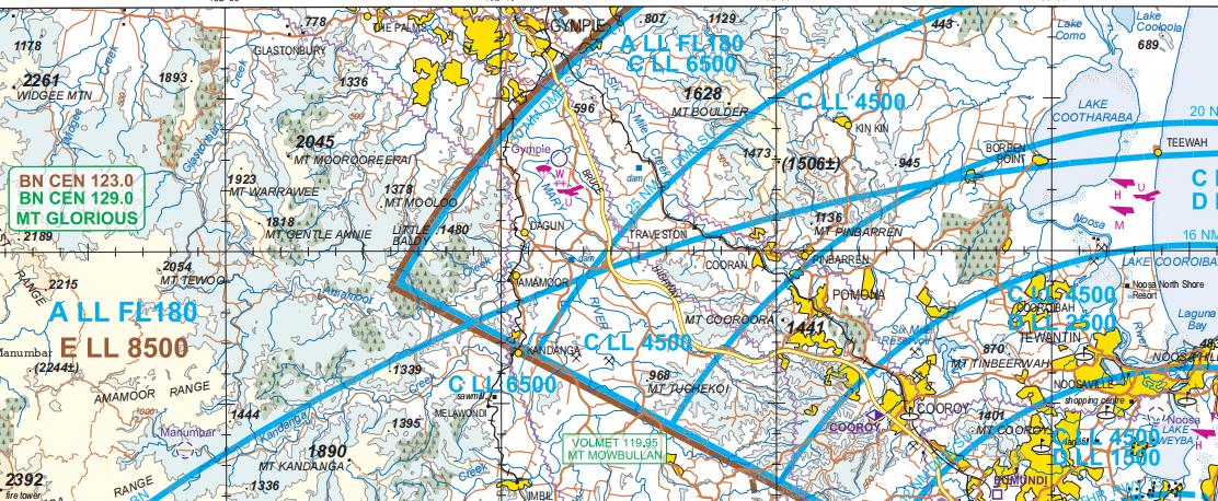
The extract below as provided by Airservices Australia shows a limited number of aeronautical features. Additional details can be seen on a typical Electronic Flight Bag chart display (below). The edge of the current ‘in the vicinity’ area around Gympie Aerodrome is shown by a black circle.

Any aerodrome with a non-generic CTAF is published as such on official aeronautical charts. Those with non-standard CTAF dimensions are also published in the En Route Supplement Australia (ERSA).
From the Visual Navigation Chart for Bundaberg, the following aerodromes are within a 100NM radius of Gympie Aerodrome with a non-generic CTAF in Class G airspace:
- Aquila YAQA – 126.55 MHz with standard dimensions
- Bundaberg YBUD – 126.90 MHz with standard dimensions
- Caboolture YCAB – 125.85 MHz with standard dimensions
- Caloundra YCDR – 125.85 MHz with standard dimensions
- Hervey Bay YHBA – 126.55 MHz with standard dimensions
- Kingaroy YKRY – 127.45 MHz with standard dimensions
- Maryborough YMYB – 126.55 MHz with standard dimensions
- North Gregory/Elliott Field YETT – 126.90 MHz with standard dimensions
- Redcliffe YRED – 125.15 MHz within a defined broadcast area SFC-BCTA
- Toowoomba YTWB – 127.65 MHz within a defined broadcast area SFC-8500 and additional operating conditions
-
Watts Bridge YWSG – 127.30 MHz with standard dimensions. Noted is Toogoolawah YTLH is within the vicinity of YWSG.
The remaining aerodromes within 100NM of Gympie Aerodrome use the generic CTAF 126.70 MHz.
Submitted by
A Gympie Aerodrome (YGYM) working party – a subcommittee of the Queensland AvSEF which included the participation and support of Gympie Regional Council as the aerodrome operator
Related links
1. Readers are encouraged to review the following official documents that provide background to aircraft operations at aerodromes in Class G airspace:
CASA Advisory Circular (AC) 91.10 – Operations in the vicinity of non-controlled aerodromes.
CASA Advisory Circular (AC) 91.14 – Pilots’ responsibility for collision avoidance in the vicinity of noncontrolled aerodromes using ‘see-and-avoid’.
Aeronautical Information Circular (AIC) H56/24 – Mitigating mid-air collision risks at non-controlled aerodromes.
The ACs are available from the CASA website and the AIC from the Airservices Australia website.
2. Another publication which contains a contemporary overview of radiocommunications in Class G airspace is:
ATSB Interim Report AO-2023-001 – Mid-air collision …, under the heading “Communications”. That report is available from the ATSB website.
3. Meetings held by Gympie Regional Council in 2017 discussing the aerodrome were held on:
10 May 2017 – Ordinary Meeting, Section 4 ‘Petitions’
28 July 2017 – Special Meeting, Section 3 ‘Corporate and Community Services’
9 August 2017 – Ordinary Meeting, Section 6 ‘Corporate and Community Services’
30 August 2017 – Ordinary Meeting, Section 4 ‘Petitions’.
Meeting minutes are available from the Council website.
4. The aerodrome operator provides information about Gympie Aerodrome in the AIP En Route Supplement Australia (ERSA – FAC section) available from the Airservices Australia website and on its own Council website.